Smelzer (Rough Creek) Cemetery
Cemetery Quick Links
Adams on CR 410
Adams on CR 262
Algerita
Baker Family
Bend
Big Uncle
Bowser Bend
Brister Ranch Grave
Brown, Shorty
Butcher
Catclaw (Weems)
Cedar Brake Cemetery
Chappel Cemetery
Cherokee (Hanna)
China Creek
Colony
Crawford
Clark, W. N. Family
Davidson
Deer Creek
Ellis (Rock Shoals)
Estep Family
Farr
Feazle Rock
Harkeyville
Harmony Ridge
Harris
High Valley
Hillcrest
Hinton
Holt
Jones
Kelley Family
King Family
Kuykendall
Latham
Linn
Locker
Mahan
Maxwell
May
McCarty
McConnell grave
McMillin
McPherson
Merrill Graves
Mesquite
Montgomery
Neel
Richland Springs (not available)
San Saba City
Shaw Bend
Sides
Sloan (Henderson)
Smelzer (Rough Creek)
Smith, John Wesley Family
Spring Creek
Sutton
Terry
Union Band
Varga Chappel
Union Band
Wallace Creek
Location: 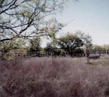
The Smelser Cemetery is located in the southeastern sector of San Saba County near the community of Chappel. The cemetery is near Rough Creek above the flood plain on the property of Maldon and Ernestine Norris.
Latitude: 31.0960oN Longitude: 98.6126oW
Directions:
- From the Court House Square at the intersection of U.S. 190 and FM 1031 (S. Live Oak) in San Saba:
- Go south on FM 1031 8.6 miles to CR 414.
- Turn left onto CR 414 and go 1.1 miles to Norris home.
- At Norris home, pass through gate and veer right onto pasture road.
- Follow this road .7 mile to cemetery. (This road is rough and rutted and leads across a narrow cattle guard.)
Conditon:
This cemetery is located in typical hill country pastureland, covered by mesquite, mountain cedar, catclaw, bee brush, prickly pear, tall prairie grass and needle grass. It covers about .6 of an acre, fenced by 3 ft. high chain link fencing with an entrance gate located at mid point in the east fence line. The cemetery is showing signs of recent neglect. Brush and trees need to be removed and heavy growth of tall grass makes it difficult to locate some gravesites.